Category Archives: Software

Addis2050: Visualizing Future Energy Scenarios

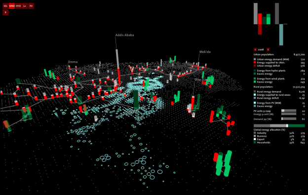
The energy scenario planning tool, developed by Eva Friedrich, has been presented at the ADDIS 2050 conference in Addis Ababa on October 9th and 10th 2012. The basic concept of the work is to create an intuitive and playful tool that allows for collaborative, interactive exploration of possible energy supply and consumption scenarios in Ethiopia. Continue reading

Corebounce & Scheinwerfer

Pascal Müller, Stefan Müller Arisona, Simon Schubiger, Matthias Specht, since 2001

Corebounce is a collective of artists and scientists with the common goal of mediating between arts, science, and technology. We maintain a number of new media projects and our own multimedia software research platform, Soundium. We are organised as a non-profit association and collaborate with a number of partners from education, in particular with ETH Zürich, and industry. Continue reading

MetroBuzz: Interactive Visualization of Urban Transportation Data

Agent based simulation tools such as MATSim and MITSIM allow us to achieve efficient and accurate predictions of crowd behavior, thereby increasing our understanding of urban systems and assist in urban planning. However, output produced by such simulation platforms are difficult to communicate to stakeholders such as government agencies and the general public due to their technical nature. Continue reading

Esri CityEngine – 3D City Modeling for Architecture, Film, and Games

Esri CityEngine, is a 3D modeling software application developed by Esri R&D Center Zurich (formerly Procedural Inc.) and is specialized in the generation of three dimensional urban environments. With the procedural modeling approach, CityEngine enables the efficient creation of detailed large-scale 3D city models with merely a few clicks of the mouse instead of the time exhaustive & work intensive method of object creation & manual placement. CityEngine works with architectural object placement & arrangement in the same manner that VUE manages terrain, ecosystems & atmosphere mapping & is equally as diverse in its ability of object manipulation & environmantal conformity/harmony as its VUE counterpart. The recent acquisition of CityEngine by Esri is aiming to push the innovations in 3D GIS and Geodesign technology (from Wikipedia). Continue reading