
Tag: Research
40 posts tagged with "Research"
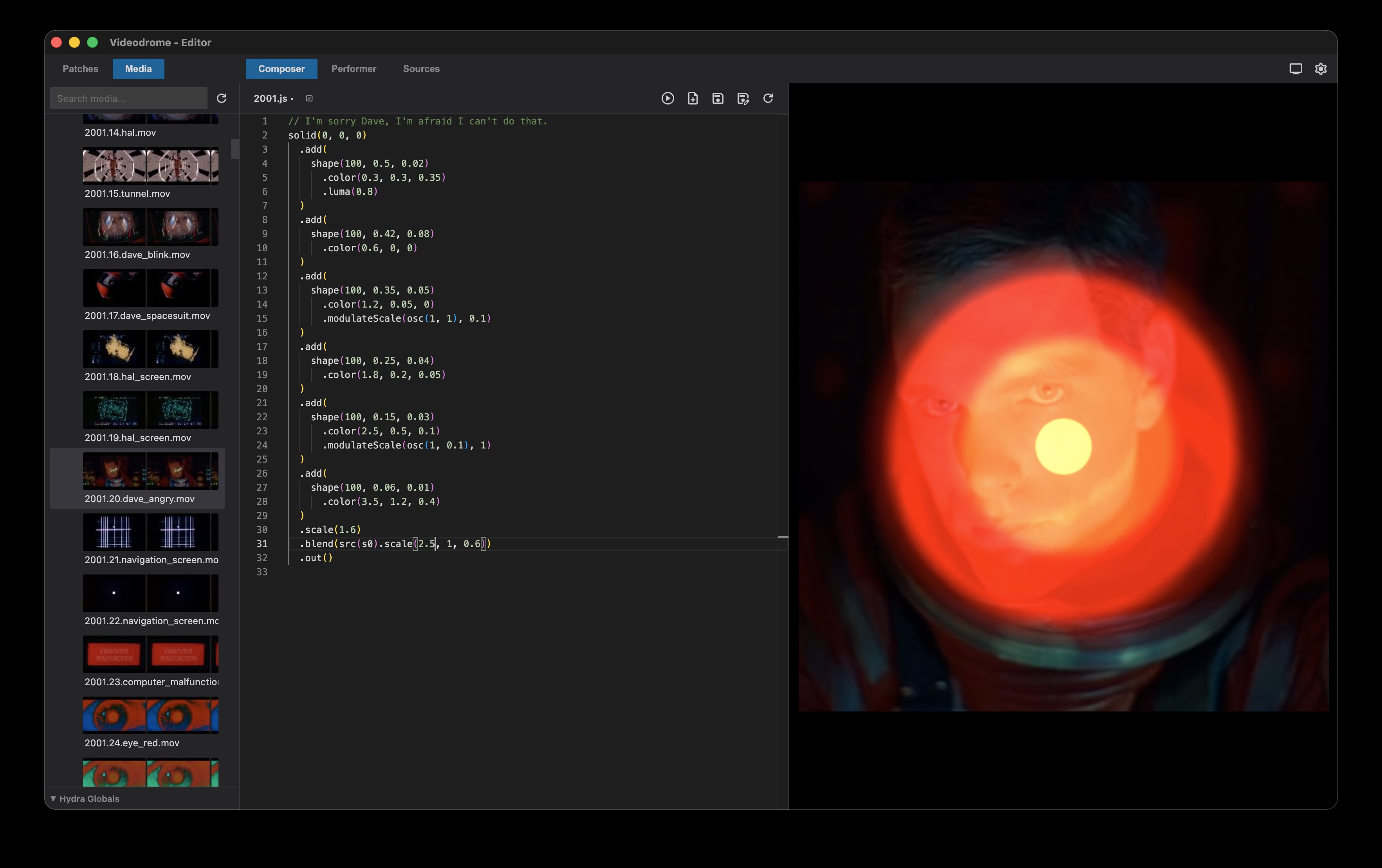
Videodrome
A live visuals environment for video synthesis using Hydra wrapped in Electron. Write and test Hydra patches in the composer and use them for live performance in the performer. Manage patches and media with two dedicated explorers and preview Hydra sources in a separate source tab.
Available on github here: https://github.com/arisona/videodrome
Book: Live Visuals - History, Theory, Practice
Edited by: Steve Gibson, Stefan Arisona, Donna Leishman and Atau Tanaka, 2022
From the publisher:
This volume surveys the key histories, theories and practice of artists, musicians, filmmakers, designers, architects and technologists that have worked and continue to work with visual material in real time.
Covering a wide historical period from Pythagoras’s mathematics of music and colour in ancient Greece, to Castel’s ocular harpsichord in the 18th century, to the visual music of the mid-20th century, to the liquid light shows of the 1960s and finally to the virtual reality and projection mapping of the present moment, Live Visuals is both an overarching history of real-time visuals and audio-visual art and a crucial source for understanding the various theories about audio-visual synchronization. With the inclusion of an overview of various forms of contemporary practice in Live Visuals culture – from VJing to immersive environments, architecture to design – Live Visuals also presents the key ideas of practitioners who work with the visual in a live context.
This book will appeal to a wide range of scholars, students, artists, designers and enthusiasts. It will particularly interest VJs, DJs, electronic musicians, filmmakers, interaction designers and technologists.
Read more on the publishers site: https://www.routledge.com/Live-Visuals-History-Theory-Practice/Gibson-Arisona-Leishman-Tanaka/p/book/9781032252681

CityEngine 3D Building Models of Berlin Mitte
This Github project contains a Esri CityEngine project with ground plane, streets, parcels and 3D models of Berlin Mitte (2x2km) based on the open data provided by Berlin’s Senatsverwaltung für Stadtentwicklung und Wohnen (https://www.stadtentwicklung.berlin.de/).
According to the copyright of the source data (see link above) you may use and modify this project as you like, but commercial use is prohibited.
The CityEngine project was originally created for a participatory urban planning application “Enabling DEMO:POLIS”, exhibited at the Berlin Academy of Arts in 2016. The source code for the application is available freely as well (see https://robotized.arisona.ch/enabling-demopolis/ for more information).
Compared to the source data, the 3D models in the CityEngine project have been cleaned up with great care (removing duplicate faces, fixing normals, merging vertices etc.). Thus, the model can easily be used for visualization, urban planning scenarios, etc.
Available on Github: https://github.com/arisona/berlin_3d
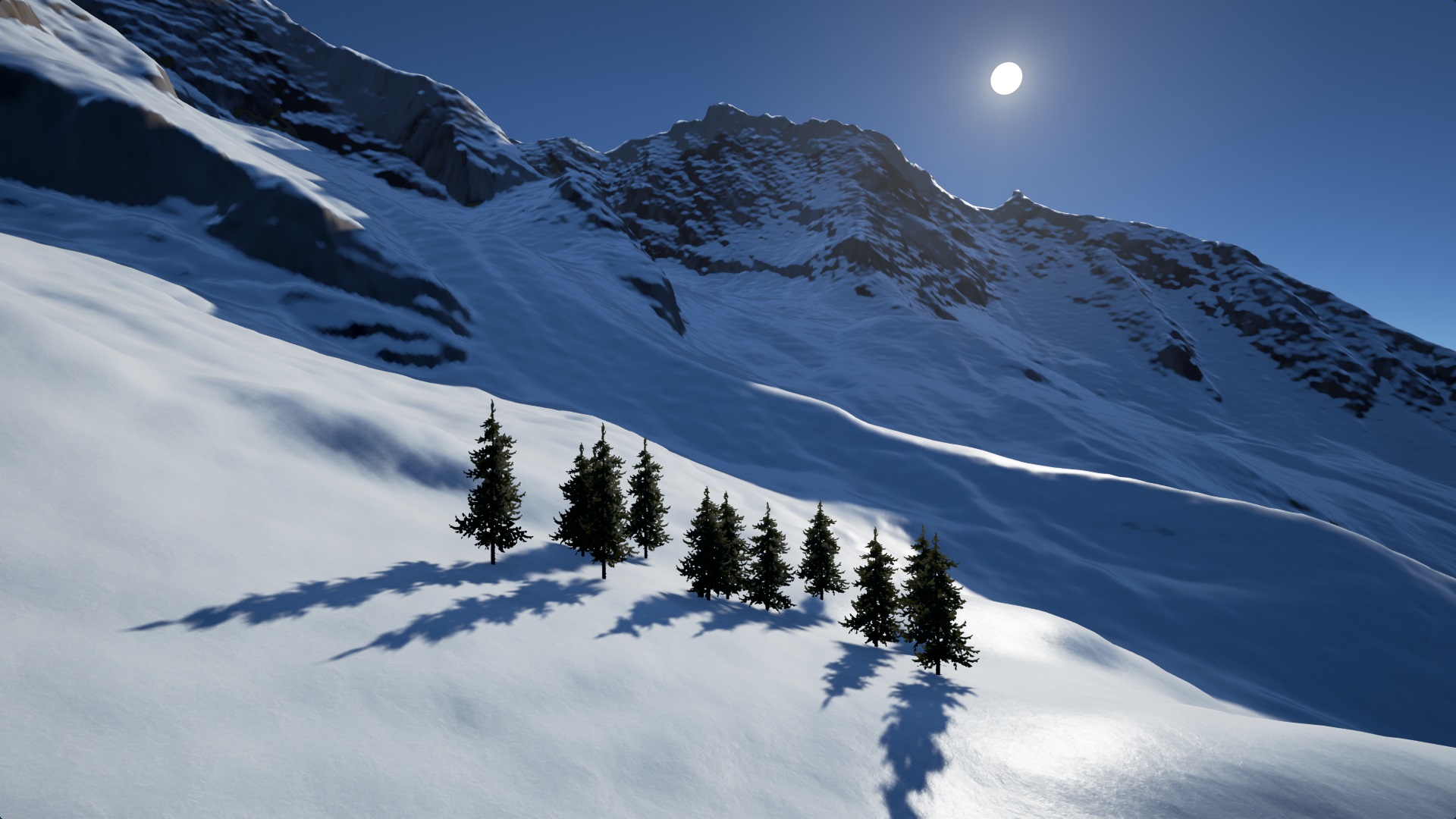
Real-Time Snow Cover Simulation (Computers & Graphics)
Title: Real-time GIS-based Snow Cover Approximation and Rendering for Large Terrains
Journal: Computers & Graphics
Authors: Benjamin Neukom, Stefan Arisona, Simon Schubiger
Abstract: Various terrain visualization techniques based on geographic information system (GIS) data already exist. One major drawback of existing visualizations is that they do not capture seasonal variations well. Besides vegetation variations, in colder areas this particularly also applies to snow cover. In this paper, we propose a real-time multi-scale snow cover approximation and visualization for large terrains. The computation runs on a large grid, calculates the snow/water equivalent based on precipitation data from a GIS and snowmelt based on a physically-based solar radiation calculation combined with a degree-day snowmelt approach using level of detail (LOD). The snow visualization is divided into two parts: Zero thickness snow cover textures are generated for distant views. For close up views the terrain’s height field is modified using displacement maps and tessellation to produce thick snow covers. The GPU-based data-parallel computation and the visualization run on the GPU in real-time on a modern desktop computer. The implementation is tested using a real area in the Swiss Alps, with a size of 14.16 by 12.88 km, a grid resolution of 222 × 206, and a time step of 1 h. We compare the rendered results spanning several months with a time series of photographs from webcams for visual accuracy.
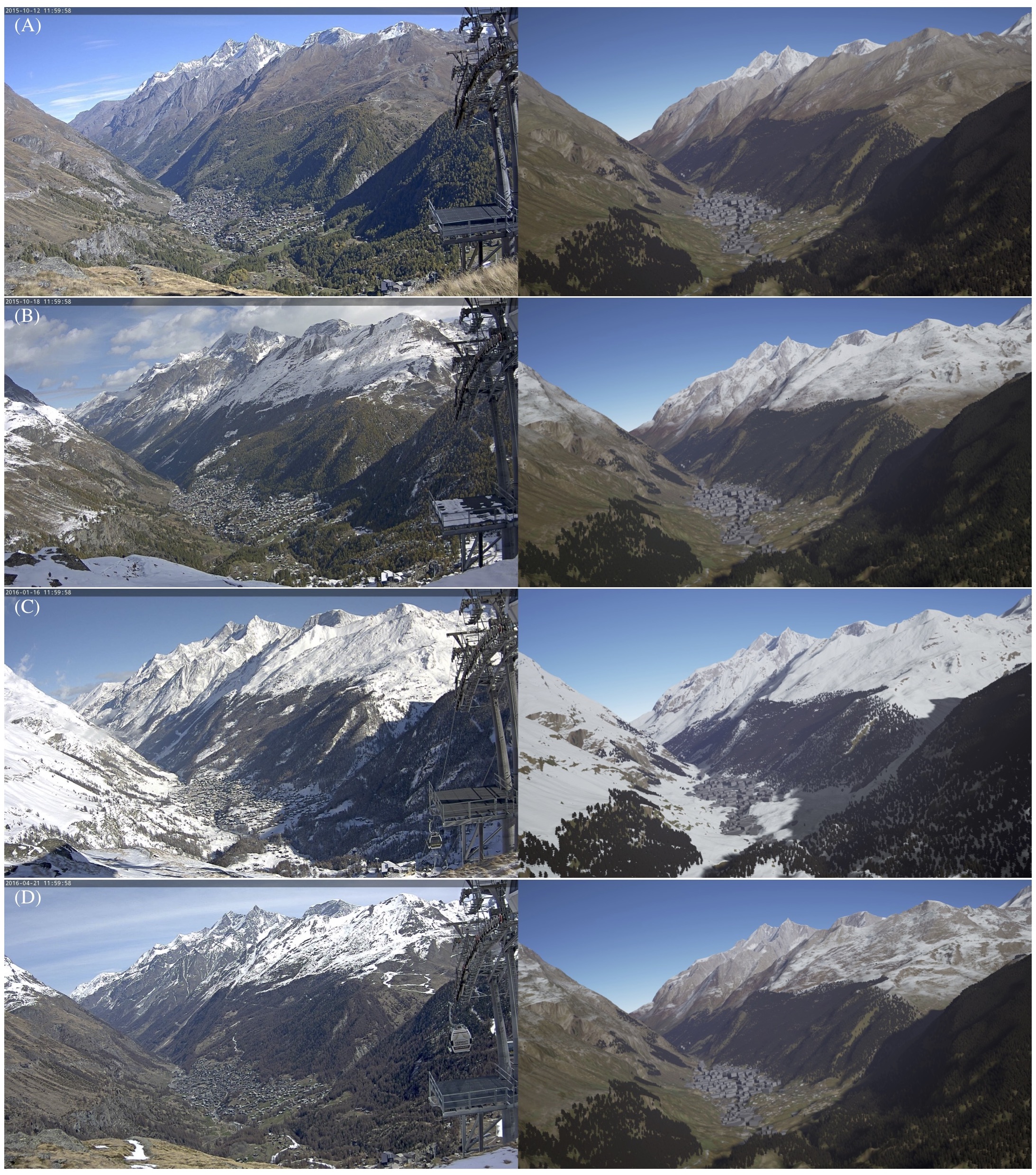
Comparison of webcam images (left) of Zermatt with our simulation (right). Trees were placed by hand and the sun position was approximated from the webcam image. (A) Start of the computation on 12.10.2015 with only the initial snow visible. (B) The results on 18.10.2015 after the first snowfall. The snowline was accurately computed. (C) The results on 16.01.2016 after the first heavy snowfall with the whole scene covered in snow. (D) The results on 21.04.2016 with snow beginning to melt as the temperature rises.
Code for Unreal Engine (open source): https://github.com/bneukom/UnrealSnow
Title: Visualizing Waypoints-Constrained Origin-Destination Patterns for Massive Transportation Data
Authors: Benjamin Neukom, Stefan Arisona, Simon Schubiger
Journal: Computers & Graphics
Publisher: Elsevier
Year: 2018
Link: https://doi.org/10.1016/j.cag.2017.10.003
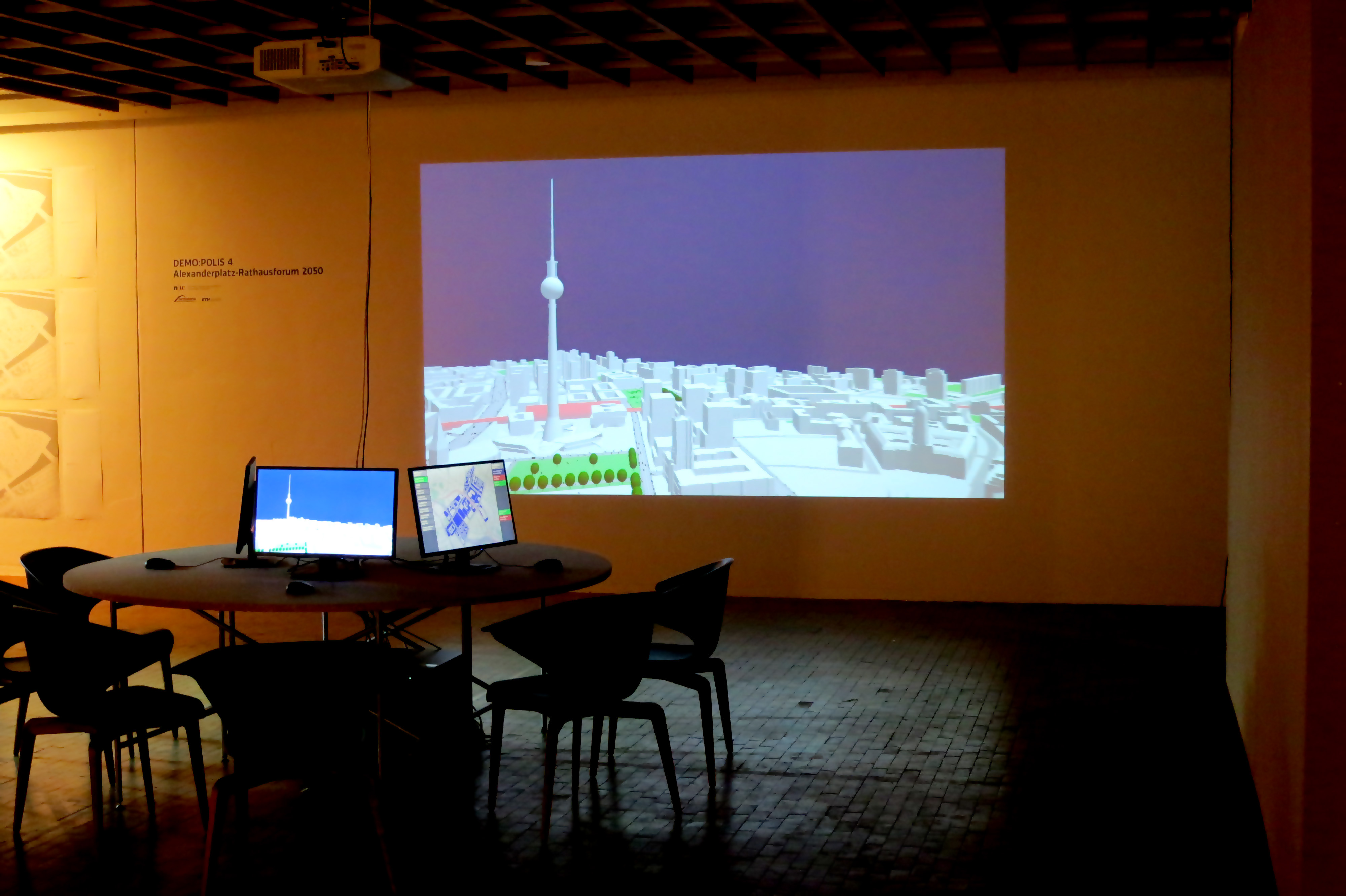
Enabling DEMO:POLIS
“Enabling DEMO:POLIS” is a participatory urban planning installation, presented as part of the DEMO:POLIS exhibition at the Berlin Akademie der Künste (https://www.adk.de/demopolis - 11.3.2016 - 29.5.2016). The installation engages the public in the design of open space and consists of six terminals that run a custom, interactive software application.
The software leads the user through a number of typical urban design tools (space allocation, streets, buildings, landscape, etc.) and concludes with a fly-through through the generated 3D scenario, in this case, the Rathausforum / Alexanderplatz area in Berlin.
The following video demonstrates a full cycle of a possible design.
Open Source
Source code, data and a binary build are available at: https://github.com/arisona
Credits
Concept: Stefan Arisona, Ruth Conroy Dalton, Christoph Hölscher, Wilfried Wang
Data & Coding: Stefan Arisona, Simon Schubiger, Zeng Wei
Support: Akademie der Künste Berlin, FHNW Switzerland (Institute of 4D Technologies), ETH Zürich (Future Cities Laboratory and Chair of Cognitive Science), Northumbria University (Architecture and Built Environment).
Data & Software Workflow
Enabling DEMO:POLIS builds on Open Data, in particular the publicly available 3D models of central Berlin provided by the Staatssenat für Stadtentwicklung und Umwelt (https://www.stadtentwicklung.berlin.de/planen/stadtmodelle/))
The original 3D models were initially imported into Autodesk AutoCAD for layer selection and coordinate system adjustments, then imported into Autodesk Maya for data cleaning and corrections. In a final step the data was imported into Esri CityEngine for final data adjustments & cleaning, merging, labelling, etc. The data was then exported as OBJs. The software application is written in Java, based on the 3D graphics library/engine ether. As indicated above, all source code and data is available as open source.