
Tag: Software
16 posts tagged with "Software"
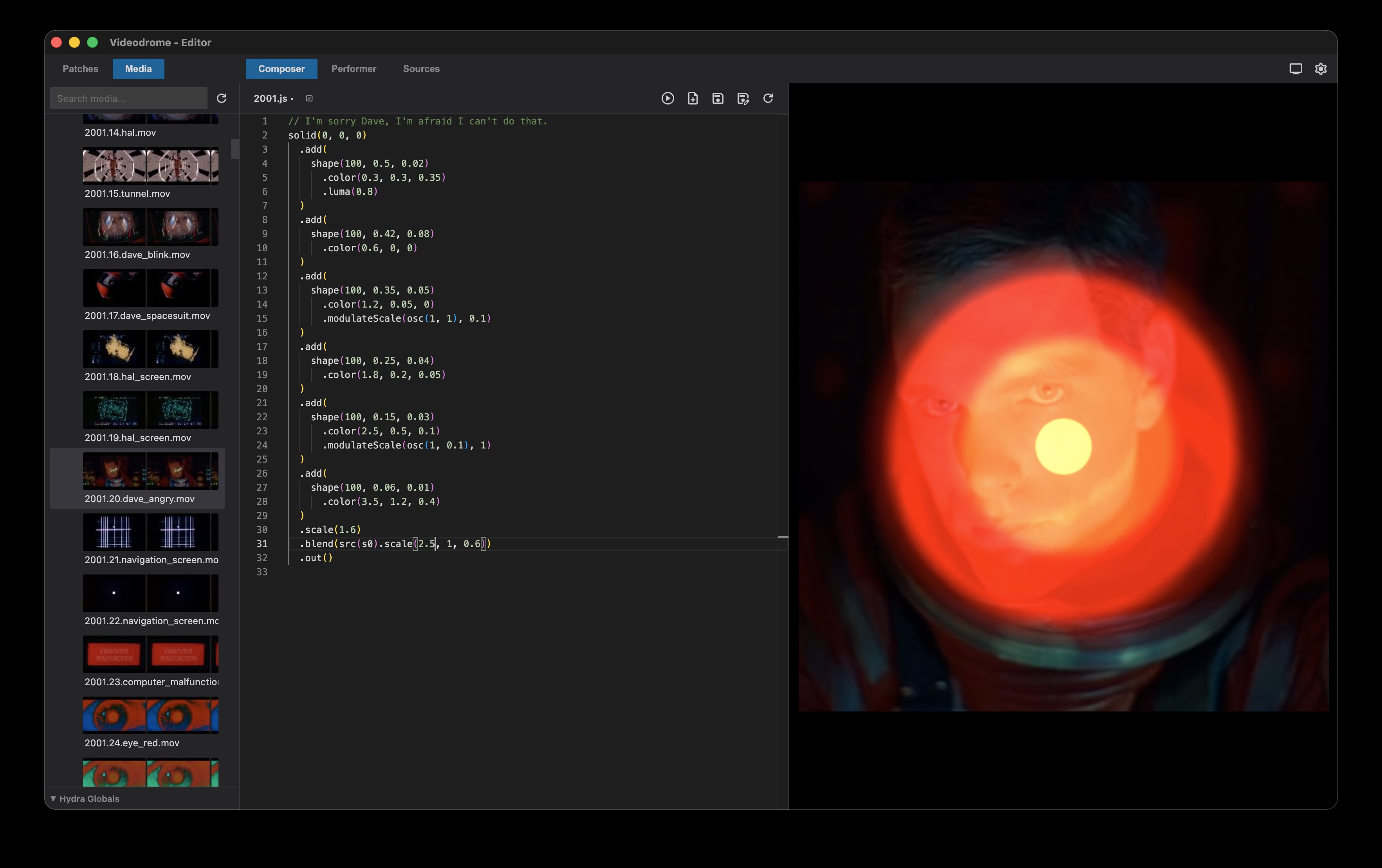
Videodrome
A live visuals environment for video synthesis using Hydra wrapped in Electron. Write and test Hydra patches in the composer and use them for live performance in the performer. Manage patches and media with two dedicated explorers and preview Hydra sources in a separate source tab.
Available on github here: https://github.com/arisona/videodrome

CityEngine 3D Building Models of Berlin Mitte
This Github project contains a Esri CityEngine project with ground plane, streets, parcels and 3D models of Berlin Mitte (2x2km) based on the open data provided by Berlin’s Senatsverwaltung für Stadtentwicklung und Wohnen (https://www.stadtentwicklung.berlin.de/).
According to the copyright of the source data (see link above) you may use and modify this project as you like, but commercial use is prohibited.
The CityEngine project was originally created for a participatory urban planning application “Enabling DEMO:POLIS”, exhibited at the Berlin Academy of Arts in 2016. The source code for the application is available freely as well (see https://robotized.arisona.ch/enabling-demopolis/ for more information).
Compared to the source data, the 3D models in the CityEngine project have been cleaned up with great care (removing duplicate faces, fixing normals, merging vertices etc.). Thus, the model can easily be used for visualization, urban planning scenarios, etc.
Available on Github: https://github.com/arisona/berlin_3d
CityEngine used in Blade Runner 2049
Designers at Framestore used ArcGIS CityEngine to re-create portions of the city of Las Vegas, Nevada, as seen in the movie Blade Runner 2049. “We were tasked in creating a futuristic Las Vegas for the year 2049. We had to fly over the main strip of Vegas on a long sequence shot,” said Didier Muanza, lead environment TD, Framestore. “CityEngine seemed to be the best choice to help us generate a modern-day model of Vegas, which was used as the base for the futuristic version.” (via ArcGIS Blog)
And: “Framestore Montreal have been successful with CityEngine on Blade Runner 2049 which is coming out this week… 400 shots in total and lots of architecture design done with CityEngine: I strongly recommend you to check it out in an IMAX near you!” (Christophe Mesline, Framestore)
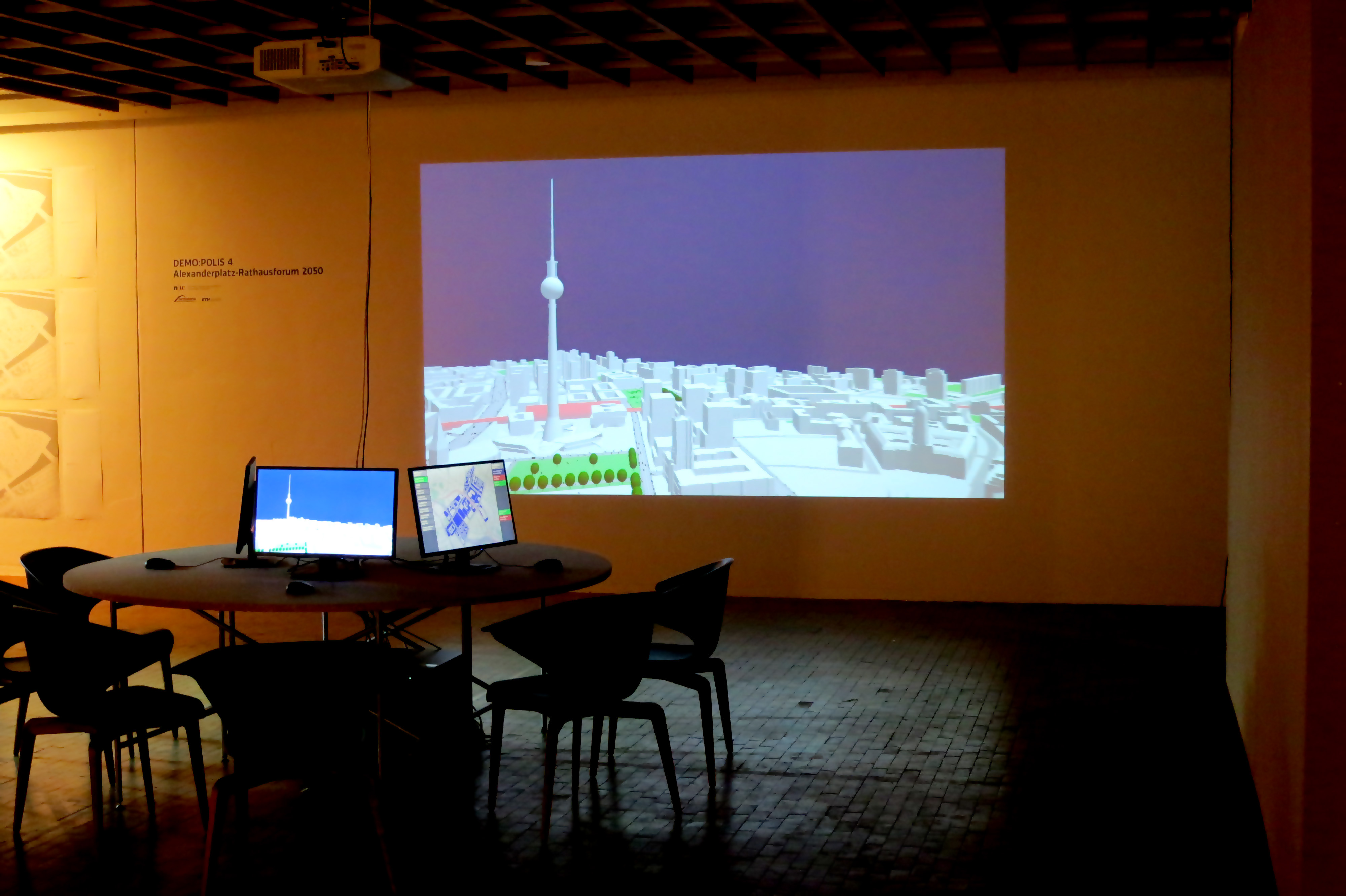
Enabling DEMO:POLIS
“Enabling DEMO:POLIS” is a participatory urban planning installation, presented as part of the DEMO:POLIS exhibition at the Berlin Akademie der Künste (https://www.adk.de/demopolis - 11.3.2016 - 29.5.2016). The installation engages the public in the design of open space and consists of six terminals that run a custom, interactive software application.
The software leads the user through a number of typical urban design tools (space allocation, streets, buildings, landscape, etc.) and concludes with a fly-through through the generated 3D scenario, in this case, the Rathausforum / Alexanderplatz area in Berlin.
The following video demonstrates a full cycle of a possible design.
Open Source
Source code, data and a binary build are available at: https://github.com/arisona
Credits
Concept: Stefan Arisona, Ruth Conroy Dalton, Christoph Hölscher, Wilfried Wang
Data & Coding: Stefan Arisona, Simon Schubiger, Zeng Wei
Support: Akademie der Künste Berlin, FHNW Switzerland (Institute of 4D Technologies), ETH Zürich (Future Cities Laboratory and Chair of Cognitive Science), Northumbria University (Architecture and Built Environment).
Data & Software Workflow
Enabling DEMO:POLIS builds on Open Data, in particular the publicly available 3D models of central Berlin provided by the Staatssenat für Stadtentwicklung und Umwelt (https://www.stadtentwicklung.berlin.de/planen/stadtmodelle/))
The original 3D models were initially imported into Autodesk AutoCAD for layer selection and coordinate system adjustments, then imported into Autodesk Maya for data cleaning and corrections. In a final step the data was imported into Esri CityEngine for final data adjustments & cleaning, merging, labelling, etc. The data was then exported as OBJs. The software application is written in Java, based on the 3D graphics library/engine ether. As indicated above, all source code and data is available as open source.
CityEngine nominated for 2015 Academy Awards
Good news: CityEngine is under consideration for the 2015 Academy Awards - the so-called “Tech-Oscars”. Fingers crossed!
Update: while we didn’t win, we’re still proud of the nomination!