
Tag: Urban Simulation
5 posts tagged with "Urban Simulation"
Enabling DEMO:POLIS
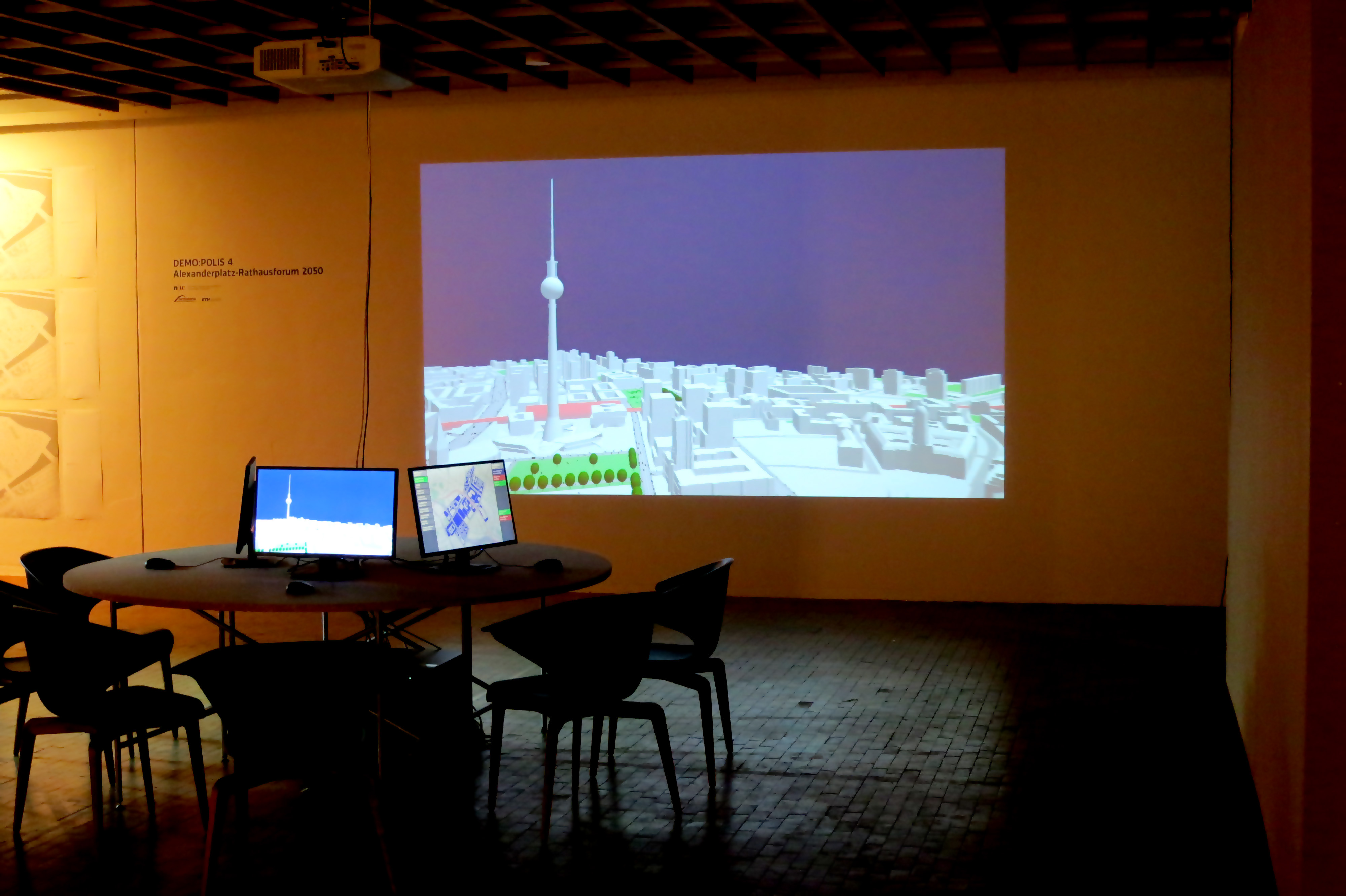
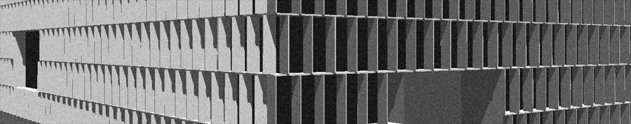
“Enabling DEMO:POLIS” is a participatory urban planning installation, presented as part of the DEMO:POLIS exhibition at the Berlin Akademie der Künste (https://www.adk.de/demopolis - 11.3.2016 - 29.5.2016). The installation engages the public in the design of open space and consists of six terminals that run a custom, interactive software application.
The software leads the user through a number of typical urban design tools (space allocation, streets, buildings, landscape, etc.) and concludes with a fly-through through the generated 3D scenario, in this case, the Rathausforum / Alexanderplatz area in Berlin.
The following video demonstrates a full cycle of a possible design.
Open Source
Source code, data and a binary build are available at: https://github.com/arisona
Credits
Concept: Stefan Arisona, Ruth Conroy Dalton, Christoph Hölscher, Wilfried Wang
Data & Coding: Stefan Arisona, Simon Schubiger, Zeng Wei
Support: Akademie der Künste Berlin, FHNW Switzerland (Institute of 4D Technologies), ETH Zürich (Future Cities Laboratory and Chair of Cognitive Science), Northumbria University (Architecture and Built Environment).
Data & Software Workflow
Enabling DEMO:POLIS builds on Open Data, in particular the publicly available 3D models of central Berlin provided by the Staatssenat für Stadtentwicklung und Umwelt (https://www.stadtentwicklung.berlin.de/planen/stadtmodelle/))
The original 3D models were initially imported into Autodesk AutoCAD for layer selection and coordinate system adjustments, then imported into Autodesk Maya for data cleaning and corrections. In a final step the data was imported into Esri CityEngine for final data adjustments & cleaning, merging, labelling, etc. The data was then exported as OBJs. The software application is written in Java, based on the 3D graphics library/engine ether. As indicated above, all source code and data is available as open source.
smartgeometry/sg13: Constructing for Uncertainty
Good news to start the year with: Our cluster proposal “Projections of Reality” has been accepted for this year’s smartgeometry at The Bartlett of UCL from 15 - 20 April 2013 in London.
Cluster gurus: Stefan Arisona, Eva Friedrich, Bruno Moser, Dominik Nuessen, Lukas Treyer.
Projections of reality will engage in augmenting design processes involving physical models with real time spatial analysis.
The cluster will explore techniques of real time spatial analysis of architectural and urban design models: how physical models can be augmented with real-time 3D capture and analysis, enabling the architect to interact with the physical model whilst obtaining feedback from a computational analysis. We will investigate possible workflows that close the cycle of designing and model making, analysing the design and feeding results back into the design cycle by projecting them back onto the physical model.
On a technical level, we are addressing the challenge of dealing with complex, unstructured data from real time scanning, e.g. a point cloud, which needs processing before it can be used in urban analysis. We will investigate strategies to extract information of the urban form targeted for design processes, using real time scanning devices (Microsoft Kinect, hand held laser scanners, etc.), open source 3D reconstruction software (reconstructMeQT) and post-processing of the input through parametric modelling (e.g. Processing, Rhino scripting, Generative Components).
The goal of the workshop will be to create a working prototype of a physical urban model that is augmented with real- time analysis. We will work with the cluster participants to formulate a design concept of the prototype and to break down the challenge into individual modules, e.g. analysing and cleaning the geometry, algorithms for real time analysis, projecting imagery onto the physical model.
Workshop applications are now open - check out these links for further information:
smartgeometry @ web: https://smartgeometry.org smartgeometry @ facebook: https://www.facebook.com/Smartgeometry
Addis2050: Visualizing Future Energy Scenarios
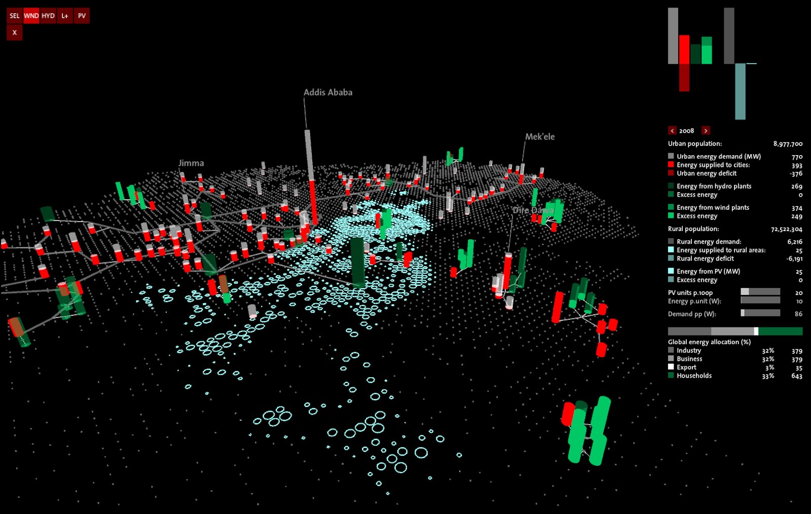
The energy scenario planning tool, developed by Eva Friedrich, has been presented at the ADDIS 2050 conference in Addis Ababa on October 9th and 10th 2012. The basic concept of the work is to create an intuitive and playful tool that allows for collaborative, interactive exploration of possible energy supply and consumption scenarios in Ethiopia. The users can move in time and compare different approaches to energy development in their effect: centralized hydro power, less-centralized wind power with local support, and completely decentralized solar power for rural, disconnected areas - thereby obtaining a better understanding of the effects of mid- to long-term energy planning.
The tool’s interface is built in a minimal style in order to keep the focus on the relevant points. It supports multi-touch surfaces, and borrows concepts from game engines, e.g. physics based animations for connecting networks.
https://www.youtube.com/watch?v=ymLicY8RHVY
The conference ADDIS 2050 – an alternative pathway into Ethiopia’s future – was held on October 9th and 10th 2012 at the campus of the Ethiopian Institute of Architecture, Building Construction and City Development EiABC in Addis Ababa. Addis Ababa belongs to the fastest growing urban centers in the world. Migration from the rural areas as well as massive redevelopment strategies of the City Government put the African capital under enormous pressure. Infrastructural deficiencies, water and energy shortages, environmental hazards and mobility challenges question the current modus operandi in place.
The Green Forum Ethiopia under the leadership of Heinrich Boell Foundation in Addis Ababa commissioned the Chair of Architecture and Construction Dirk E. Hebel at FCL Singapore in collaboration with the Ethiopian Institute of Architecture, Building Construction and City Development EiABC to invent an alternative “green” scenario for the city of Addis Ababa in the year 2050. The conference concentrated on the issues of Energy, Mobility, Cultural and Social Space, Housing and Information. The event was visited by more than 500 people and arose immense interest from the media as well as the City Administration. As guest of honor, the Swiss Ambassador H.E. Dominik Langenbacher attended the conference as well as delegates from several federal ministries and the UN-Habitat. In the meantime, the Department of Masterplanning and Vision of the City Adeministration invited the speakers to present the work in their offices.
Team FCL Singapore: Dirk Hebel, Felix Heisel, Marta Wisniewska, Alireza Javadian, Gerhard Schmitt, Stephen Cairns, Remo Burkhard, Eva-Maria Friedrich, Matthias Berger, Stefan Mueller Arisona, Ludger Hovestadt, Jorge Orozco, Alex Erath, Max Hirsh, Sonja Berthold, Ying Zhou, Edda Ostertag, Naomi Hanakata, Lindsey Ann Sawyer, Cheryl Song, Noor Faizah Binte Othman, Kevin Lim, Amanda Tan
Team EiABC: Joachim Dieter, Bisrat Kifle, Addis alem Fekele, Tewedaj Eshetu, Yosef Teferri, Eyob Wedesu
Team Green Forum/Heinrich Boell Foundation: Patrick Berg, Ayele Kebede, Jonas
Software Design and Development: Eva Friedrich
Energy Modelling: Matthias Berger
Principal Investigators: Gerhard Schmitt & Stefan Arisona
Institution: Future Cities Laboratory, ETH Zürich
Period: August / September 2012
Book: Digital Urban Modeling and Simulation
Edited by Stefan Arisona, Gideon Aschwanden, Jan Halatsch, and Peter Wonka, 2012
About this Book
This book is thematically positioned at the intersections of Urban Design, Architecture, Civil Engineering and Computer Science, and it has the goal to provide specialists coming from respective fields a multi-angle overview of state-of-the-art work currently being carried out. It addresses both newcomers who wish to obtain more knowledge about this growing area of interest, as well as established researchers and practitioners who want to keep up to date. In terms of organization, the volume starts out with chapters looking at the domain at a wide-angle and then moves focus towards technical viewpoints and approaches. (Excerpt from preface by Stefan Arisona).
Contents
Part I: Introduction
A Planning Environment for the Design of Future Cities - Gerhard Schmitt
Calculating Cities - Bharat Dave
The City as a Socio-technical System: A Spatial Reformulation in the Light of the Levels Problem and the Parallel Problem - Bill Hillier
Technology-Augmented Changes in the Design and Delivery of the Built Environment - Martin Riese
Part II: Parametric Models and Information Modeling
City Induction: A Model for Formulating, Generating, and Evaluating Urban Designs - José P. Duarte, José N. Beirão, Nuno Montenegro, and Jorge Gil
Sortal Grammars for Urban Design: A Sortal Approach to Urban Data Modeling and Generation - Rudi Stouffs, José N. Beirão, and José P. Duarte
Sort Machines - Thomas Grasl and Athanassios Economou
Modeling Water Use for Sustainable Urban Design - Ramesh Krishnamurti, Tajin Biswas, and Tsung-Hsien Wang
Part III: Behavior Modeling and Simulation
Simulation Heuristics for Urban Design - Christian Derix, Åsmund Gamlesæter, Pablo Miranda, Lucy Helme, and Karl Kropf
Running Urban Microsimulations Consistently with Real-World Data - Gunnar Flötteröod and Michel Bierlaire
Urban Energy Flow Modelling: A Data-Aware Approach - Diane Perez and Darren Robinson
Interactive Large-Scale Crowd Simulation - Dinesh Manocha and Ming C. Lin
An Information Theoretical Approach to Crowd Simulation - Cagatay Turkay, Emre Koc, and Selim Balcisoy
Integrating Urban Simulation and Visualization - Daniel G. Aliaga
Part IV: Visualization, Collaboration and Interaction
Visualization and Decision Support Tools in Urban Planning - Antje Kunze, Remo Burkhard, Serge Gebhardt, and Bige Tuncer
Spatiotemporal Visualisation: A Survey and Outlook - Chen Zhong, Tao Wang, Wei Zeng, and Stefan Arisona
Multi-touch Wall Displays for Informational and Interactive Collaborative Space - Ian Vince McLoughlin, Li Ming Ang, and Wooi Boon Goh
Testing Guide Signs’ Visibility for Pedestrians in Motion by an Immersive Visual Simulation System - Ryuzo Ohno and Yohei Wada
Publication Information
Publisher: Springer, Berlin Heidelberg
Series: Communications in Computer and Information Science, Vol. 242
Editors: Arisona, S.; Aschwanden, G.; Halatsch, J.; Wonka, P.
Year: 2012
ISBN: 978-3-642-29757-1
Link: https://www.springeronline.com/978-3-642-29757-1
ETH Zurich's Singapore-ETH Centre and the Future Cities Laboratory
The Singapore-ETH Centre for Global Environmental Sustainability (SEC) in Singapore was established as a collaboration between the National Research Foundation of Singapore and ETH Zurich in 2010. It is an institution that frames a number of research programmes, the first of which is the Future Cities Laboratory (FCL). The SEC strengthens the capacity of Singapore and Switzerland to research, understand and actively respond to the challenges of global environmental sustainability. It is motivated by an aspiration to realise the highest potentials for present and future societies. SEC serves as an intellectual hub for research, scholarship, entrepreneurship, postgraduate and postdoctoral training. It actively collaborates with local universities and research institutes and engages researchers with industry to facilitate technology transfer for the benefit of the public.
https://www.futurecities.ethz.ch/
I have been involved in Future Cities Laboratory since my return from UCSB in October 2008, and was the second PI to move to Singapore in October 2010, at that time located at temporary offices at the NUS School of Design and Environment. Main tasks included general ramp up of the centre, establishing technical infrastructure, hiring and supervision of PhD students. In January 2012, SEC moved into its permanent offices at the Singapore National Research Foundation (NRF) Campus for Research Excellence and Technological Enterprise (CREATE). I was responsible for the design and implementation of the [[ValueLabAsia |Value Lab Asia]], which was built in only three months and has been in operation since March 2012.
The Simulation Platform Research Module (“Module IX”): Service and Research for Future Planning Environments
Informing design and decision-making processes with new techniques and approaches to data acquisition, information visualisation and simulation for urban sustainability.
In science, simulations have assumed a critical role in mediating between theory and practical experiment. In architecture, simulations increasingly function in a similar way to help integrate the design, construction, and lifecycle management of buildings. And in urban planning, simulations have become an indispensable method for generating and analysing design and planning scenarios. The growing importance of simulation for these fields has been stimulated by a rapid growth in the availability of urban-related data. Despite this, most current simulations are capable of capturing and activating only a small fraction of the available data. Addressing this lack is both a matter of generating appropriate computer power to process the vast bodies of data, and accessing the data itself that is often held in hard to access databases. To contemplate possible advanced urban planning techniques that activate live and dynamic data, demonstrates that existing tools, such as GIS, are ill equipped to exploit the analytical and communicative potentials of this growing volume of urban data.
The Simulation Platform examines how to effectively deal with the growing volume of urban-related data. It investigates new techniques and instruments for the acquisition, organisation, retrieval, interaction, and visualisation of such data. It will propose techniques for designers, decision-makers and stakeholders to access necessary data about the city in innovative and dynamic ways. It does in two ways. First, it supports other research modules in the Future Cities Laboratory by supplying services such as data acquisition methods and visualisation facilities. Second, building on these services it will conduct original research on advanced and dynamic modelling, visualisation and simulation techniques that aim to better understand and intervene in the complex processes that shape contemporary cities.
Module Leader & PI: Prof Dr Gerhard Schmitt
Module Coordinator & PI: Assoc Prof (Adj) Dr Stefan Arisona
PIs: Prof Dr Armin Grün, Prof Dr Ludger Hovestadt, Prof Dr Ian Smith
Affiliated Faculty: Assoc Prof Dr Tat Jen Cham (NTU), Assoc Prof Dr Chandra Sekhar (NUS), Assoc Prof Dr Ian McLoughlin (NTU), Asst Prof Dr Philip Chi-Wing Fu, Asst Prof Dr Benny Raphael (NUS), Prof Dr Luc Van Gool (ETH Zurich), Asst Prof Dr Jianxin Wu (NTU)
PostDocs: Dr Matthias Berger, Dr Xianfeng Huang, Dr Tao Wang
PhD Students: Gideon Aschwanden, Dengxin Dai, Eva Friedrich, Vahid Moosavi, Maria Papadopoulou, Rongjun Qin, Dongyoun Shin, Sing Kuang Tan, Didier Vernay, Wei Zeng, Chen Zhong
IT Engineers: Daniel Sin, Chan Lwin